

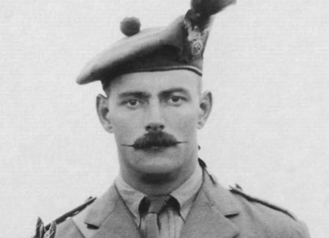
Percival William Anderson
Story by Phlis McGregor, CBC
When Jim MacDonald makes his pilgrimage to Vimy Ridge on Sunday, he will be guided by a 100-year-old map, which is stained with mud from the First World War battlefield, and now sits carefully folded in archival paper at his Cape Breton home.
The map was carried by a young soldier, Percival William Anderson, as he led his men up Hill 145 on the evening of April 9, 1917. It shows trenches and German strongpoints, with lines and symbols added in Anderson’s own hand.
"I can imagine him with that map from morning to night," says MacDonald, an author and researcher in Baddeck, N.S.
Read more on CBC WEBSITE


0
Log In or Sign Up to add a comment.- 1
arrow-eseek-eNo items to displayFacebook Comments